Cultural Heritage Services
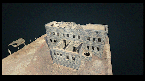
Explore our exceptional historical site preservation service where we use state-of-the-art drones and innovative software solutions to craft stunning 3D textured models of cherished heritage locations.
Step into the future while preserving the past with our cutting-edge Drone Heritage Services. At Mirzam Spectrum, we understand the importance of safeguarding our rich history and cultural heritage. Our specialized drone technology allows us to capture stunning aerial imagery and create detailed 3D textured models of historical sites, ensuring that their essence remains intact for generations to come.
Imagine walking through time as you navigate these meticulously detailed 3D models, each texture and contour thoughtfully preserved to offer an immersive experience. Our service isn't just about creating visuals; it's about preserving the past for generations to come. With our intricate models, researchers, educators, and enthusiasts can delve into the intricate architecture and stories of these sites.
Our cloud platform enhances the storage, accessibility, and presentation of these models, making them easily available whenever and wherever you need them.
Our dedicated team of experts combines the art of drone piloting with a deep appreciation for history. By leveraging the power of remote sensing, we meticulously document heritage sites from various angles, capturing intricate details that might be missed by the naked eye. These visuals provide an invaluable resource for historians, archaeologists, and enthusiasts alike, enabling them to study, analyze, and appreciate the past in an entirely new light.
Why Choose Our Drone Heritage Services?
- Preservation: By employing the latest drone technology, we contribute to the preservation of cultural heritage sites that might otherwise be susceptible to natural deterioration or human interference.
- Accuracy: Our drones capture high-resolution imagery, creating accurate 3D models that capture the essence and intricacies of historical sites down to the finest details.
- Accessibility: Through our services, historical sites become accessible to a global audience. Anyone with an internet connection can explore these sites virtually, fostering a deeper understanding and connection to the past.
- Collaboration: We collaborate with historians, archaeologists, and heritage professionals to ensure our data aligns with their research needs and contributes to the broader understanding of our history.
At Mirzam Spectrum, we're more than a drone service provider; we're stewards of history. Join us in our mission to safeguard history through cutting-edge technology. With our historical site preservation service, the past comes to life, and the future gains a richer perspective.

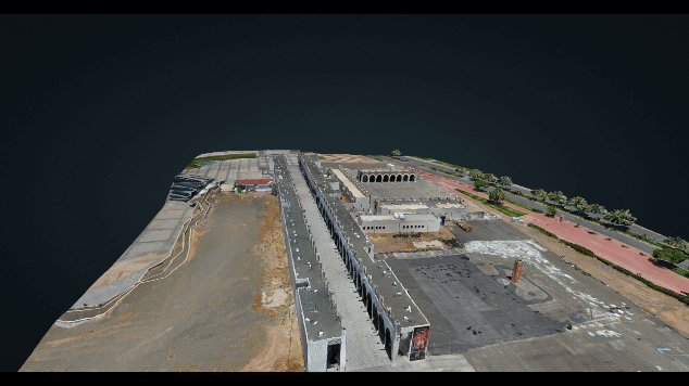
Urban Planning Services
Experience the future of urban planning through our advanced Drone Services. At Mirzam Spectrum, we empower city planning with innovative technology, transforming traditional challenges into streamlined solutions. Our services encompass:
City Modeling: Unlock the potential of 3D reality models that accurately depict landforms and architectural details, enabling efficient and effective design and planning.
Urban-Rural Classification: Stay up-to-date with accurate 2D maps and 3D models, ensuring precise landscape classification for informed decision-making.
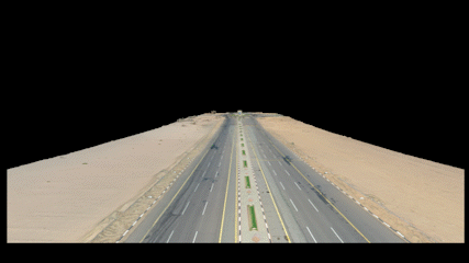
Corridor Mapping: Swiftly map crucial corridors like rivers, bridges, and roads with precise 2D and 3D models, simplifying maintenance and inspections.
Solving Traditional Challenges:
- Seamlessly integrate BIM designs, road vector maps, Google maps, and satellite imagery by leveraging precise position data, saving time and effort.
- Enhance visualizations by overcoming the limitations of 2D designs, presenting comprehensive spatial information.
- Bridge the gap between BIM designs and reality models, enabling accurate design verification and visualization.
Drone Advantages in City Modeling:
- Expedite data collection through automated flights, reducing costs and fieldwork hours.
- Integrate geo-referenced 3D models seamlessly into BIM designs, providing a visual representation of planning concepts.
- Compatible 3D models, generated using photogrammetry software, enhance planning processes by integrating with various GIS software.
Corridor Mapping Service
Discover a new dimension in Corridor Mapping with Mirzam Spectrum. We revolutionize traditional practices, providing unparalleled precision and efficiency. Our Corridor Mapping service tackles:
Overcoming Traditional Hurdles:
- Traditional methods fall short in delivering high-resolution 3D geographic representations.
- Complex environments with roads, bridges, and water infrastructure challenge accurate mapping.
- Manual mapping of corridor structures like rivers and power lines leads to prolonged timelines and increased costs.
Harnessing Drone Mapping Solutions:
- Our surveying drones and advanced software amalgamate diverse geographic data, crafting detailed 2D orthomosaics and 3D models for classification and planning.
- Intelligent drone features navigate intricate terrains, maintaining flight safety while upholding data precision.
Empowering with Compatibility:
- Navigate complexities effortlessly as our drones operate flawlessly in varied terrains, ensuring both safety and data accuracy.
- Generate 2D maps and 3D models compatible with a range of GIS software, facilitating swift visualization for prompt adjustments.
At Mirzam Spectrum, we redefine Corridor Mapping. Elevate your projects with cutting-edge drone solutions that deliver accuracy, and efficiency.